
The county's draft Charlbury plan lists 38 walking and cycling schemes, led by a Forest Road gateway by the station and a Pooles Lane traffic ban. Comments close 29 October.
Oxfordshire County Council has published a draft walking and cycling plan for Charlbury and is asking for comments until 29 October. Charlbury is about six miles north of Witney. The plan lists 38 numbered schemes, from a zebra crossing on Nine Acres Lane to an all-weather cycle route to Stonesfield.
The council announced the consultation on Friday 9 October. The draft Charlbury Area Local Cycling and Walking Infrastructure Plan runs to 122 pages. It was first drafted by the county in December 2024, reworked by Charlbury Town Council in October 2025, and put into the county’s template in July 2026.
One detail to note on the date. The consultation page says the consultation “closes on Monday 29th October 2026”. That date is a Thursday. The council’s release gives 29 October without a day, so treat 29 October as the deadline.
What the plan is for
A Local Cycling and Walking Infrastructure Plan, or LCWIP, does not build anything by itself. It identifies routes, lists improvements and ranks them, so that the council has a scheme ready when funding appears. The plan says delivery “will depend on further feasibility studies, detailed design, public consultation and funding opportunities”.
Charlbury’s is a pilot for a small rural town. The county’s framework was written for market towns, so the formal walking and cycling route audits used elsewhere were dropped as disproportionate. The plan says that, given Charlbury’s size, “no formal auditing or public engagement was carried out” before this draft. The section headed “public engagement results” is empty and will be filled after this consultation.
The plan covers Charlbury itself plus the links to Finstock, Fawler, Enstone, Stonesfield and Spelsbury.
The schemes that score highest
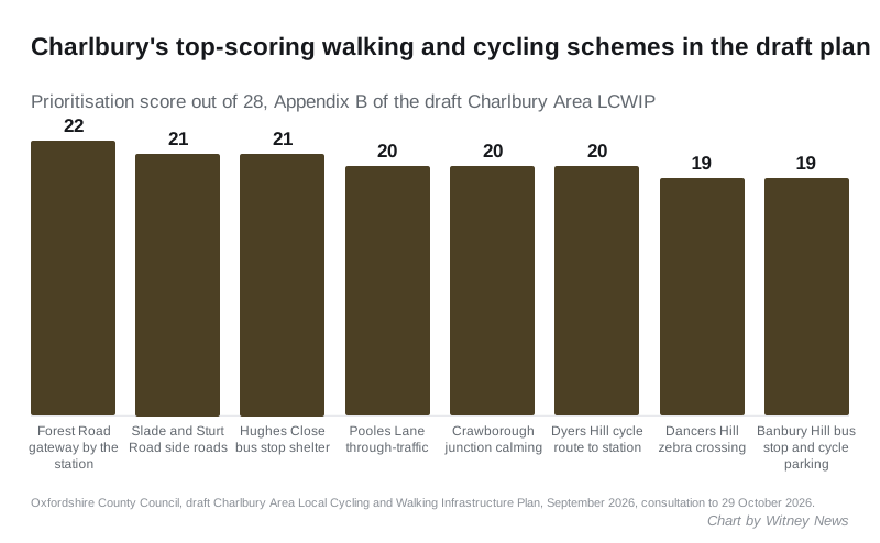
Every scheme has been scored out of 28 against the county’s criteria: effectiveness, policy fit, deliverability and environmental benefit. The ranked table is in Appendix B.
The top of the list:
- Forest Road gateway, 22 points, ranked first. A gateway treatment on the B4437 where the national speed limit drops to the local limit, west of Charlbury station.
- The Slade and Sturt Road side roads, 21. Narrower junctions and continuous footways at Ditchley Road, Ticknell Piece Road and Dancers Hill, to improve routes to school.
- Hughes Close bus stop, 21. A shelter and real-time information at the stop opposite Hughes Close, “used by many secondary school pupils”.
- Pooles Lane, 20. Traffic management on part of National Cycle Route 442, with options including one-way working or a ban on motor vehicles except for access between Fishers Lane and the Playing Close.
- Crawborough, 20. A motor vehicle ban except for access, narrowing at the Slade junction and parking restrictions, for a safer route to Charlbury Primary School.
- Dyers Hill cycle improvements, 20. Design work to make cycling from the town to the station “safe, attractive and comfortable”.
- Dancers Hill zebra crossing and the Banbury Hill bus stop, 19 each.
Four schemes score 18: public realm work at Bull corner and along Market Street, measures to discourage through-traffic on Park Street, Church Street and Market Street, a pedestrian crossing on Banbury Hill, and signs to Wigwell Nature Reserve.
Other proposals worth knowing about
Several schemes would change how traffic moves, not just where people walk:
- Dyers Hill bridge would lose a lane. The plan proposes widening the footway and reducing the carriageway to a single lane with a give-way, with vehicles leaving town having priority. It scores 17.
- Park Street and Grammar School Hill would get a give-way for motor vehicles, with traffic coming from Park Street having priority.
- The Slade would lose its central hatching and the right-turn lane into Ticknell Piece Road, to make room for marked parking bays.
- Gateway features are proposed on Woodstock Road at the Charlbury sign and on the B4026 between Pound Hill and Spelsbury Road.
- The Spendlove Centre would get a continuous footway across its vehicle access, a marked walkway through the car park and resurfacing on Enstone Road to give pedestrians priority between the Playing Close and the Co-op.
The cycling routes out of town are mostly on tracks the county does not own:
- Stonesfield via the Oxfordshire Way bridleway, which the plan calls “of particular importance” because it would link Charlbury to the Woodstock, Kidlington, Witney, Carterton and Eynsham plans
- Finstock through Cornbury Park on National Cycle Route 442, with muddy sections resurfaced
- Enstone via Ditchley Road and the Salt Way restricted byway
- Spelsbury, with traffic calming and a longer 20mph limit on the B4026
The plan flags each of the bridleway and estate routes as needing landowner consent, and the Route 442 sections as needing agreement with the Walk, Wheel, Cycle Trust.
Councillor Liz Leffman, the county’s Cabinet Member for Highways, Construction and Repair, said in the release: “We want to hear from residents on the improvements you would like to see to make local travel on foot, bike or using a mobility aid simpler and better for you.”
What it means for you
- Comments close on 29 October. Use the survey on the Let’s Talk Oxfordshire page, or email placeplanningnorth@oxfordshire.gov.uk. Paper copies are available on 01865 792422.
- The plan is a shopping list, not a works programme. After the consultation the final version goes to a Cabinet Member decision and becomes council policy. Schemes are then built as money is found, through developer contributions, government funds or county programmes.
- The county says it especially wants to hear from people who find walking, wheeling or cycling in Charlbury difficult, and whether the plan meets their needs.
- If you drive through Charlbury, the Pooles Lane, Crawborough, Dyers Hill bridge and Park Street schemes are the ones that would change your route or your priority.
Witney does not yet have a plan of this kind. The Charlbury document refers to Witney, Carterton and Eynsham LCWIPs as plans that the Stonesfield route would eventually connect to. We will cover the Witney plan when the county publishes it. The town’s current road closures are on our roadworks and travel page.
Sources
- Share your thoughts on active travel proposals for Charlbury, Oxfordshire County Council, 9 October 2026 for the deadline and the quote.
- Charlbury and the surrounding area LCWIP, Let’s Talk Oxfordshire for the consultation dates and how to respond.
- Draft Charlbury Area Local Cycling and Walking Infrastructure Plan, September 2026 (PDF, 122 pages) for the version history, the scope, every scheme described above and the scores in Appendix B.
Have your say